Blog

  • VARIoT, the cybersecurity of connected objects

    VARIoT, the cybersecurity of connected objects

    VARIoT, the cybersecurity of connected objects

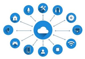
    The development of the Internet of Things (IoT) raises the crucial question of the security of connected objects, which are particularly vulnerable to attacks. Télécom SudParis is involved in the research and development of cybersecurity technologies and is particularly interested in IoT security through the European collaborative research project VARIoT (Vulnerability and Attack Repository for IoT).  Here’s a look at an ambitious and promising project.

    The creation of the project

    The VARIoT project was set up by Grégory Blanc, a teacher-researcher at Télécom SudParis, lecturer in cybersecurity and networks, coordinator of the third-year specialization in systems and network security, and head of European and national projects.

    After completing his engineering school internship in a research laboratory in Japan, Grégory Blanc continued his studies with a thesis in the field of cybersecurity. “The topic was related to client-side scripting, the objective being to protect the browser against attacks that can be organized via malware-infected websites,” says Grégory Blanc.

    Back in France, the young researcher obtained a postdoc at Télécom SudParis, with Professor Hervé Debar. In 2012, the opportunity arose to participate in a European project in collaboration with Japan. This first project paved the way for collaborations such as the VARIoT project. Initiated by a European call for projects from the Innovation and Networks Executive Agency (INEA), this project, which began in 2019 and ends in 2022, involves five European partners on the IT security of connected objects.

    Why should we be concerned about the security of connected objects?

    Being mass-produced and having a short time-to-market, connected objects are subject to failures in terms of computer security. Since their resources are limited, once the operating system and various applications are installed, they have little memory left for security software. Security often has to be outsourced, which results in a notorious vulnerability of these objects to attacks.

    “For objects connected to the Internet via a wireless connection, updates can be vulnerable to interception (or Man-in-the-Middle attacks) when integrity and authenticity guarantees are lacking: when requests and responses are not encrypted, the attacker can modify their content, especially if the object does not verify the identity of the update server,” explains Gregory Blanc.

    “Another very common vulnerability is the administration web portal, like the Telnet service, used as an administration interface by many objects. You can connect to it using the administration credentials, which are often left as the default (e.g. admin/admin). Mirai is known to exploit this vulnerability.

    The attacks work by scanning the Internet for objects responding on the Telnet port that have weak authentication, i.e. with no or insufficiently protective passwords. It is then possible to take control of the objects and install new programs or generate requests on other entities on the Internet in order to create, for example, distributed denial of service attacks (saturation of communication capacities),” says Grégory Blanc.

    The basis of the project

    The purpose of VARIoT is to make all the data in the world on the vulnerabilities of connected objects and the attacks that target them available via a set of European web portals. Implementation of the web portal is supported by Carnot Télécom & Société numérique. The consortium set up to support the project is made up of Télécom SudParis, the Polish research institute NASK, the Dutch Shadowserver foundation, the Computer Incident Response Center  in Luxembourg and Mondragon University (Spain).


    Télécom SudParis brings its expertise in intrusion detection. “Our approach is to observe communication on the networks and try to determine whether the messages are issued by legitimate or malicious entities,” says Grégory Blanc. In the VARIoT project, a number of objects have been deployed in realistic conditions, interacting with humans to generate real traffic. This legitimate network profile is integrated into machine learning algorithms, so that an anomaly can be identified as soon as it appears. This prevents connected objects that have been infected from sending messages outside the network where they are located. Signatures of previously infected objects will also be collected to provide network behavior profiles of malware. This task is being carried out by Mondragon University, which has proposed a platform to reproduce the infection of an object and capture the network traffic, once this compromised object generates messages.

    A collaborative network

    © European Data Portal/Facebook

    Télécom SudParis also shares its data and IoT traffic models on the web portal (variot.telecom-sudparis.eu).

    Shadowserver scans the entire Internet regularly to identify threats and share them with its network of partners. Since the beginning of the VARIoT project, Shadowserver has been scanning connected objects to identify them and study their security levels. Aggregation of data and constitution of a database is managed by NASK.

    A threat analysis on IoT objects is coordinated by Smile, an entity working under the CERT (Computer Emergency Response Team) in Luxembourg, who have proposed to use an information exchange platform (MISP) between CERTs on a global level, and to share cybersecurity data sources of connected objects across Europe on the European Data Portal.

    The benefits

    The project has a very concrete focus on improving IoT cybersecurity.  By providing more detailed knowledge of vulnerabilities and threats to connected objects, it will enable the development of tools capable of anticipating and preventing the occurrence of threats.

    Moreover, since network data on connected objects is rare and difficult to obtain (due to the protection of privacy and personal data), generating this data will provide visibility and enable the evaluation of intrusion detection tools developed at Télécom SudParis.

    The contacts that are being established with Yokohama National University for collaboration on these topics illustrate the broad interest in this work.

    Contact Carnot TSN

    Olivier Martinot

    Director of Innovation and Corporate Relations

    Telecom SudParis 

  • Detecting attacks on UAVS

    Detecting attacks on UAVS

    Detectings attacks on UAVS

    This article was initially published on I’MTech, the scientific and technological news blog of Institut Mines-Télécom.


    A UAV (or drone) in flight can fall victim to different types of attacks. At Télécom SudParis, Alexandre Vervisch-Picois is working on a method for detecting attacks that spoof drones concerning their position. This research could be used for both military and civilian applications.

    He set out to deliver your package one morning, but it never arrived. Don’t worry, nothing has happened to your mailman. This is a story about an autonomous drone. These small flying vehicles are capable of following a flight path without a pilot, and are now ahead of the competition in the race for the fastest delivery.

    While drone deliveries are technically possible, for now they remain the stuff of science fiction in France. This is due to both legal reasons and certain vulnerabilities in these systems. At Télécom SudParis, Alexandre Vervisch-Picois, a researcher specialized in global navigation satellite systems (GNSS), and his team are working with Thales to detect what is referred to as “spoofing” attacks. In order to prevent these attacks, researchers are studying how they work, with the goal of establishing protocol to help detect them.

    How do you spoof a drone?

    In order to move around independently, a drone must know its position and the direction in which it is moving. It therefore receives continuous signals from a satellite constellation which enables it to calculate the coordinates of its position. These can then be used to follow a predefined flight path by moving through a succession of waypoints until it reaches its destination. However, the drone’s heavy reliance on satellite geolocation to find its way makes it vulnerable to cyber attacks. “If we can succeed in getting the drone to believe it is somewhere other than its actual position, then we can indirectly control its flight path,” Alexandre Vervisch-Picois explains. This flaw is all the more critical given that the drones’ GPS receivers can be easily deceived by false signals transmitted at the same frequency as those of the satellites.

    This is what the researchers call a spoofing attack. This type of cyber attack is not new. It was used in 2011 by the Iranian army to capture an American stealth drone that flew over its border. The technique involves transmitting a sufficiently powerful false radio frequency to replace the satellite signal picked up by the drone. This spoofing technique doesn’t cancel the drone’s geolocation capacities as a scrambler would. Instead, it forces the GPS receiver to calculate an incorrect position, causing it to deviate from its flight path. “For example, an attacker who succeeds in identifying the next waypoint can then determine a wrong position to be sent in order to lead the drone right to a location where it can be captured,” the researcher explains.

    Resetting the clocks

    Several techniques can be used to identify these attacks, but they often require additional costs, both in terms of hardware and energy. Through the DIGUE project (French acronym for GNSS Interference Detection for Autonomous UAV)[1] conducted with Thales Six, Alexandre Vervisch-Picois and his team have developed a method for detecting spoofing attempts. “Our approach uses the GPS receivers present in the drones, which makes this solution less expensive,” says the researcher. This is referred to as the “clock bias” method. Time is a key parameter in satellite position calculations. The satellites have their time base and so does the GPS receiver. Therefore, once the GPS receiver has calculated its position, it measures the “bias”, which is the difference between these two time bases.  However, when a spoofing attack occurs, the researchers observed variations in this calculation in the form of a jump. The underlying reason for this jump is that the spoofer has its own time base, which is different from that of the satellites. “In practice, it is impossible for the spoofer to use the same clock as a satellite. All it can do is move closer to the time base, but we always notice a jump,” Alexandre Vervisch-Picois explains. To put it simply, satellites and spoofer are not set to the same time.

    One advantage of this method is that it does not require any additional components or computing power to retrieve the data, since they are already present in the drone. It also does not require expensive signal processing analyses in order to study the information received by the drone–which is another defense method used to determine whether or not a signal originated from a satellite.

    But couldn’t the attacker work around this problem by synchronizing with the satellites’ time setting? “It is very rare but still possible in the case of a very sophisticated spoofer. This is a classic example of measures and countermeasures, exemplified in interactions between a sword and a shield. In response to an attack, we set up defense systems and the threats become more sophisticated to bypass them,” the researcher explains. This is one reason why research in this area has so much to offer.

    After obtaining successful results in the laboratory, the researchers are now planning to develop an algorithm based on time bias monitoring. This could be implemented on a flying drone for a test with real conditions.


    [1] Victor Truong’s thesis research

  • FarmIA, digital engineers for connected permaculture

    FarmIA, digital engineers for connected permaculture

    FarmIA, digital engineers for connected permaculture

    With their project for connected and responsible farming supported by Deepnet and JustAI, these students from Télécom SudParis might just change agricultural production as we know it. Their goal is to maximize yields while eliminating as much waste as possible. 


    FarmIA: AI and robotics supporting connected permaculture

    FarmIA is an organization founded by ten first-year engineering students from Télécom SudParis: Ariane Lang, Mohamed Chamrouk, Louise Oligiati, Gibril Gunder, Quentin Puzenat, Rémi Boileau, Lucas Delsol, Émilien Vannier, Makarije Spasic and Antonin Desmerges.

    Their project was carried out as part of the Gate® educational program (Management and Teamwork Training), which trains first-year students in working as a team.

    FarmIA uses a robot that is directly connected with the farmer. The organization combines two types of technology: FarmBot–a robot adapted for agriculture–and artificial intelligence the students have developed. The robot is programmed to analyze the plants and identify their needs in terms of care and nutrients.

    The primary goal is ecological. In the long-term, shortages resulting from a lack of fertile land are likely to skyrocket. We must therefore change our agricultural habits to prevent putting future generations at risk.


    A project recognized by Fondation Sopra Steria-Institut de France

    The theme of the 17th edition of the Entrepreneurship for Tomorrow Award, organized by Sopra-Steria-Institut de France and sponsored by explorer and tech investor Luc Hardy, was “Responsible digital technology for the planet”. This edition called on young people to take action to promote responsible digital technology.

    On October 6, ten of our students impressed the judging panel, earning an award in the “Student” category. FarmIA won this Entrepreneurship for Tomorrow Award because their idea tackles a 21st-century challenge, that of taking action for the environment while still remaining economically competitive. For nearly one year, these students were able to test their innovative project on the Télécom SudParis campus using a 2 by 6 meter box.


    Human impacts kept at a minimum

    Permaculture optimizes agricultural yield to enable the small-scale construction of sustainable housing that is in harmony with nature. In this situation, human intervention is limited to the use of water, space and energy. The idea is to integrate biodiversity, which has proven to greatly reduce soil pollution compared to intensive monoculture farming.

    Our ten engineering students have highlighted the role of crop rotation. By keeping the resources required to grow plants at a minimum, water and energy costs can be reduced.

    FarmIA therefore enables improved yield while minimizing resources. Both economical and environmentally-friendly, connected farming may well be the future of agriculture. However, while its effectiveness in vegetable gardens has been proven, there is still work to be done regarding its use in larger farms.


  • Biomica platform : At the cutting edge of medical imaging

    Biomica platform : At the cutting edge of medical imaging

    Among the research platforms at Télécom SudParis, BioMICA has developed bio-imaging applications that have already been approved by the medical field. Airways, its 3D representation software, received funding from Télécom & Société Numérique Carnot Institute

    One of the recommendations included in the March 2017 France AI Strategy report was to put artificial intelligence to work to improve medical diagnosis. The BioMICA research platform (which stands for Bio-Medical Imaging & Clinical Applications) has made this goal its mission.

    We aim to develop tools that can be used in the clinical setting,” says Catalin Fetita, professor at Télécom SudParis and director of the bio-medical imaging platform. “Our applied research focuses on computer-aided diagnosis involving medical and biological imaging,” he explains. As a specialist in image analysis and processing, Catalin Fetita offers the platform true expertise in the area of medical imaging, particularly in lung imaging.

    AirWays, or another way of seeing lungs

    AirWays is “image marker” software (like biomarkers in biology). Based on a sequence of lung images taken by a scanner, it extracts as much information as possible for clinicians to assist them in their diagnosis by offering a range of different visualization and classification options. “The quantitative aspect is very important, we do not only want to offer better visual quality,” Catalin Fetita explains. “We offer the possibility of obtaining improved measurements of morphological differences in several areas of the respiratory system at different moments in time. This help clinicians decide which treatment to choose.” In terms of quantified results, the software can detect 95% of stenosis cases, which is the narrowing of bronchial tubes that affects respiratory capacity.

    AirWays software uses a graphic grid representation of bronchial tube surfaces after analyzing clinical images and then generates 3D images to view them both “inside and outside” (above, a view of the local bronchial diameter using color coding)This technique allows doctors to plan more effectively for endoscopies and operations that were previously performed by sight.

    “For now, we have limited ourselves to the diagnosis-analysis aspect, but I would also like to develop a predictive aspect,” says the researcher. This perspective is what motivated Carnot TSN to help finance AirWays in December 2017. “This new budget will help us improve and optimize the software’s interface and increase its computing power to make it a true black box for automatic and synthetic processing,” explains Catalin Fetita, who also hopes to work towards commercializing the software.

    A platform for medicine of the future

    In addition to its many computer workstations for developing its medical software, the BioMICA platform features two laboratories for biological experimentation. One of the laboratories has a containment level of L1 (any biological agent that is non-pathogenic for humans) and the other is L2 (possible pathogen with low risk). Both will help advance the clinical studies in cellular bio-imaging.

    In addition, Catalin Fetita and his team are preparing a virtual reality viewing station to provide a different perspective of the lung tissue analyzed by Airways. “Our platform works thanks to research partnerships and technological transfers,” he explains, “but we can also use it to provide services for clinical studies.”

  • Data-Mobility or the art of modeling travel patterns

    Data-Mobility or the art of modeling travel patterns

    The French have a saying that reflects the daily routine of millions of Parisians: “métro-boulot-dodo” (metro-work-sleep).  While this seems to be the universal experience for Il-de-France residents, individual variations exist. Some individuals only use public transport via one of the two major networks, RATP or SNCF, but others prefer driving. There are also those who change from the metro to the RER train, or leave their car part way and take a train. All of this information can be found through mobile data analysis. Vincent Gauthier, associate research professor at Télécom SudParis, has become a specialist in the area.

    Using mobile networks to understand mobility

    Determining someone’s travel itinerary based on the mobile data provided by their operator is not an easy task. “A telephone only transmits its GPS position to applications that request it, such as Waze,” Vincent Gauthier explains. “The only knowledge an operator can use to establish a person’s geographic location is which mobile base stations they were connected to during their travels.” The French telephone network, which is shared between different operators including Orange, SFR and Bouygues, forms an irregular grid pattern (see Fig. 3). The different relay or base stations provide a network connection based on clearly defined zones. When a person leaves a zone, they automatically enter another one, and their telephone connects to the new corresponding base station. The size of these zones varies in each region. In the Ile-de-France region, a large number of base stations are concentrated and clustered together in Paris, but there are much fewer in the Seine-et-Marne region.

    Using mobile networks to understand mobility

    Fig. 1 : Method used to aggregate the transport networks to closely analyze the route taken.

    Fig. 2 : Origin-destination matrix for a day in the Ile-de-France region.

    Fig. 3 : Grid pattern for the mobile network base stations.

    Data-Mobility or the art of modeling travel patterns

    The information produced from these connections only allows origin-destination matrices that are more or less detailed to be established. As an expert in the graphical representation of large volumes of data (Fig. 2), Vincent Gauthier wants to take this analysis a step further: “How does a person travel? Why? Where does the person live? How many other people take the same route? Answering these questions could help us optimize mobility options.”

    To reproduce the exact route an individual takes based on this non-specific information, he has worked on a new method with another researcher from Télécom SudParis, Mounim El Yacoubi (ARMEDIA team–EPH department).

    From optimizing transportation to geodemographics

    Mounim and I have patented a method for automatically processing routes, which allows us to determine what types of transport a person has taken during their journey,” Vincent Gauthier explains. Thanks to their “method for route estimation using mobile data”, the two researchers can superimpose the different transport networks over the information the operators receive from the base stations (Fig. 1). “To identify the most likely road or rail journey the users have taken based on their route, we must use a huge database including the locations of the base stations, train stations and the maps of the different transport networks.” They are currently working with Bouygues to develop route estimations in “near real time”.

    In their work, the two researchers are drawing on previous socio-demographic studies they conducted in Milan and in Africa. “We participated in estimating population density in the Ivory Coast and Senegal,” explains Vincent Gauthier. “The goal was to provide socio-demographic data that was lacking in these countries, so that the United Nations could establish more reliable statistics.”

    Vincent Gauthier’s work goes beyond simply modeling big data; his expertise leads us to rethink the geography of our regions: “By analyzing individuals’ routes and optimizing transport options accordingly, we could possibly divide the Ile-de-France region into more relevant sub-areas.”

  • Research activities

    Research activities

    Research serving innovation and economic development

    Our research strategy draws on the expertise of faculty members who produce high-quality, relevant research.

    Our mission: respond to the challenges of the future while supporting the digital transformation of society, the economy, and companies, through ambitious scientific projects.

    Telecom SudParis faculty members undertake high-level research, responding to major challenges in contemporary society. In close connection with industrial stakeholders, research is mainly performed at the school’s SAMOVAR laboratory.

    Faculty members contribute to four interdisciplinary centers at Institut Polytechnique de Paris: Hi!Paris for artificial intelligence (fr), Energy 4 Climate for environmental aspects of digital technology, the Interdisciplinary Center for Defense and Security (fr), Engineering for Health Interdisciplinary Center (E4H) and SPIRAL – Interdisciplinary Center Science, People, Imagination, Research, Art, all Linked (SPIRAL).


    106

    faculty members

    110

    PhD students

    28

    patents in our portfolio

    5 M€

    revenue from research contracts

    5 key areas

    Fields of scientific research at the SAMOVAR laboratory:

    • Applied Mathematics
    • Computer Science
    • Networks
    • Physics and Communications Technologies
    • Signals and Image

    Major challenges

    Research is undertaken for sectors leading the digital transformation:

    • Digital industry/industry of the future
    • Health and assisted living for individuals
    • Energy/energy transition/smart grids
    • Digital cities/smart mobility
    • Artificial intelligence

    Strategic themes

    Our researchers respond to national and international calls for projects and address a broad range of multidisciplinary issues though areas of excellence:

    • New distributed and virtual architectures for systems and networks (cloud, fog, software defined networking, containers, edge computing, Internet of Things, middleware)
    • Data processing methods and tools (artificial intelligence, machine learning, statistics, semantic web, onthologies)
    • Network models (optimization, energy efficiency, complexity, deployment, management)
    • Methods and tools for signal processing and digital communications (high-speed broadband, optics, filtering, smoothing, classification, indoor positioning systems)
    • Methods and tools for image and multimedia data processing (3D modeling, multi-modal and multi-sensor imaging)
    • Digital trust (cybersecurity and personal data protection, specifications, proof and tests)
    • Optics and photonics (new components for networks)
    • Fields of application: communication networks and systems of the future, Internet of Things, digital health, the environment, industry of the future, smart cities, intelligent transportation systems, smart grids.


    Have a question?


    • Research and Doctoral Training Department
    • Innovation and Corporate Relations Department
    • IMT Starter Incubator
    • Director of the SAMOVAR Laboratory


    Contact us here

This site is registered on wpml.org as a development site. Switch to a production site key to remove this banner.